Hurricane Paulette is taking aim at Bermuda, bringing a threat of serious flooding and damaging winds, according to the National Hurricane Center.
“Paulette Moving Closer to Bermuda. Strong Winds. Storm Surge. And Heavy Rain Expected to Begin On Bermuda By This Evening,” the center tweeted early Sunday.
HURRICANE SEASON PEAK: HERE’S WHY SEPT. 10 IS DAY MOST LIKELY TO HAVE A TROPICAL STORM

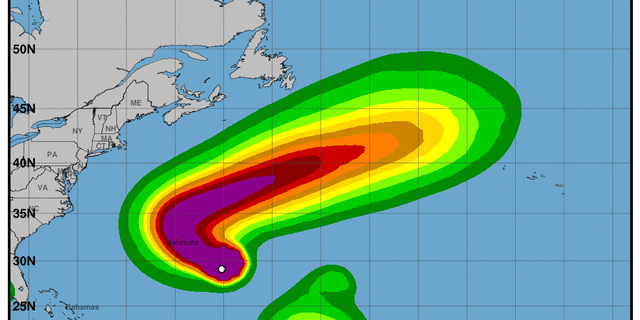
NOAA/National Weather Service graphic showing the probability of tropical storm-force winds associated with Hurricane Paulette.
(NOAA/NWS)
Residents of the island were urged to prepare to protect life and property ahead of Paulette, which gained hurricane status late Saturday.
“Hazardous southeasterly swells and surf quickly become dangerous today,” the Bermuda Weather Service said in a statement early Sunday. “Outer bands may bring showers and squally conditions ahead of the storm. Expect tropical storm force winds to develop by early this afternoon and hurricane force winds Sunday night with the storm centre passing nearby early Monday morning.”
TIPS FOR USING A GENERATOR SAFELY DURING A HURRICANE
At 5 a.m. EDT Sunday Paulette was traveling west-northwest at 14 mph with maximum sustained winds of 75 mph, the National Hurricane Center said.
CLICK HERE TO GET THE FOX NEWS APP
“On the forecast track, the center of Paulette will move near or over Bermuda Monday morning,” the center said in an advisory. “Strengthening is forecast, and Paulette is expected to be a dangerous hurricane when it approaches Bermuda late tonight and early Monday. Some further strengthening is possible when Paulette turns northeastward and moves away from Bermuda late Monday through Tuesday.”
The Associated Press contributed to this story.
Follow James Rogers on Twitter @jamesjrogers