The peak of the hurricane season is just days away and forecasters on Sunday have their eyes on four potential areas for tropical development out in the Atlantic basin.
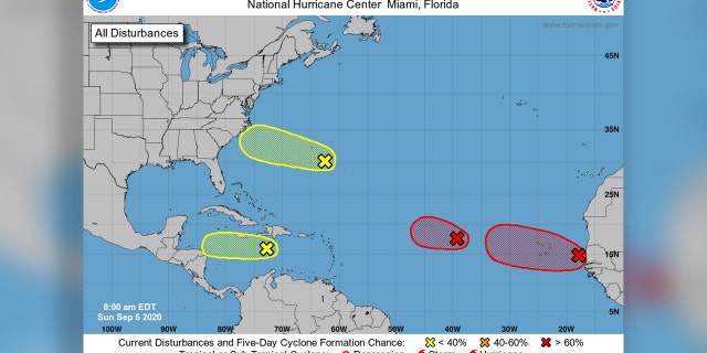
The U.S. National Hurricane Center (NHC) in Miami said that two systems in the eastern part of the Atlantic basin are “likely” to become tropical depressions over the next five days.
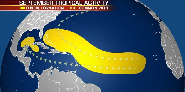
Historically, September produces the most Atlantic Ocean basin tropical activity.
HURRICANE SEASON COMPUTER MODELS SHOW NEW SYSTEMS DEVELOPING OFF AFRICA
Forecasters said that one area of low pressure located midway between the west coast of Africa and the Leeward Islands is “gradually becoming better defined,” but is still a disorganized area of showers and thunderstorms.
The NHC says there’s a high, or 90% chance, that a tropical depression forms in the next 48 hours while the system continues to move westward.

Four areas of possible tropical development are being monitored by the National Hurricane Center.
(NHC)
If named, this system would be “Paulette” and potentially set a record for the earliest “P”-named tropical system, according to Colorado State University hurricane research scientist Phil Klotzbach.
The second area of disturbed weather is also being monitored for organization as it moves off the coast of western Africa. This area has about an 80% chance of formation over the next five days while it continues to move westward over the far eastern Atlantic.
“Interests in the Cabo Verde Islands should monitor the progress of this system as gusty winds and locally heavy rainfall is possible there on Monday and Tuesday,” the NHC said.
In the western portion of the Atlantic, a tropical wave located over the central Caribbean Sea is producing disorganized showers and thunderstorms on Sunday.
The NHC only puts this area at a 10% chance of development over the next five days, adding that any formation would only happen in the next day or two as it moves across the Caribbean.
HURRICANE NANA MAKES LANDFALL IN BELIZE, BRINGS FLOODS TO HONDURAS; OMAR TO DISSIPATE
“After that time, unfavorable upper-level winds should limit its formation chances,” the NHC said.
Another area of disturbed weather located a couple of hundred miles southeast of Bermuda is producing showers, but there are only “marginally conducive” conditions for development while the system moves west.
The NHC said there’s only a 20% chance of development over the next five days.
This 2020 season has been active so far, with several storms breaking records for their respective letter for how early they formed.
CLICK HERE FOR MORE WEATHER COVERAGE FROM FOX NEWS
The two most recent storms, Nana and Omar, were the earliest 14th and 15th named storms on record, beating the 2005 arrivals of Nate on Sept. 6 and Ophelia on Sept. 7, according to Klotzbach.

Where tropical systems tend to develop in the month of September.
(Fox News)
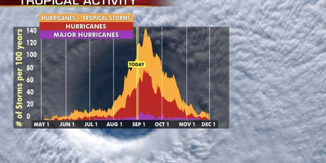
Hurricane season has now entered its busiest month, as activity historically climbs through Sept. 10, when it peaks and starts to slowly go back down.

The historic peak of hurricane season is September 10th.
(Fox News)
Historically, about two-thirds of all Atlantic hurricane activity happens between Aug. 20 to Oct. 10, Klotzbach tweeted earlier this month.
NOAA forecasters are now calling for up to 25 named storms with winds of 39 mph or higher; of those, seven to 10 could become hurricanes. Among those hurricanes, three to six will be major, classified as Category 3, 4 and 5 with winds of 111 mph or higher.

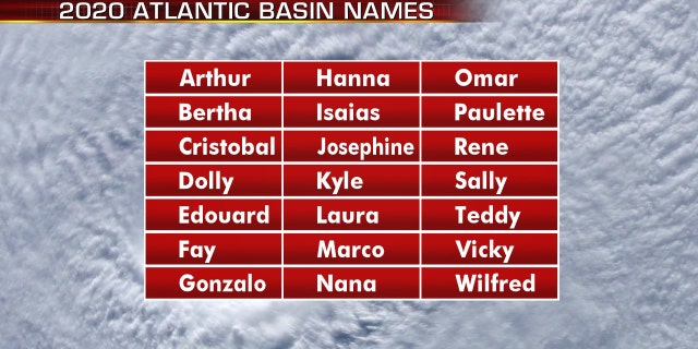
The names for the 2020 Atlantic hurricane season.
(Fox News)
That’s far above an average year. Based on 1981 to 2010 data, that is 12 named storms, six hurricanes and three major hurricanes. So far this year, there have been 15 named storms, including five hurricanes.
CLICK HERE FOR THE FOX NEWS APP
The 2020 Atlantic hurricane season runs from June 1 to Nov. 30 and includes the names: Arthur, Bertha, Cristobal, Dolly, Edouard, Fay, Gonzalo, Hanna, Isaias, Josephine, Kyle, Laura, Marco, Nana, Omar, Paulette, Rene, Sally, Teddy, Vicky and Wilfred.
Fox News’ Adam Klotz and Brandon Noriega contributed to this report.