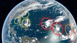
Two of them are named Paulette and Rene, and both are currently located over the central Atlantic Ocean.
The other five are what we refer to as tropical waves or disturbances. Storm systems that aren’t yet tropical storms but have the potential to become storms within the next five days. Three of these systems are near the US.
The first, a low pressure located just off the coast of North Carolina, is producing a few showers and thunderstorms.
“This system is expected to move inland over eastern North Carolina this afternoon, and therefore significant development is not expected,” the National Hurricane Center says on its website.
The second system is currently in the eastern Gulf of Mexico. It is a very weak cluster of storms right now but may potentially strengthen as it moves into the western Gulf over the next several days.
The third system is currently a large group of showers and thunderstorms northeast of the Central Bahamas. This system is forecast to move westward, crossing both the Bahamas and Florida by this weekend. Once it reaches the Gulf of Mexico early next week, it will have to potential to strengthen.
The system to really watch for is a new tropical wave moving off the west coast of Africa, producing a large area of showers and thunderstorms. This system is expected to intensify over the next few days, and has a 90% chance of becoming a named system in the next five days as it moves generally westward across the Atlantic Ocean.
Table Of Contents
La Niña is officially here
Today, the National Oceanic and Atmospheric Administration (NOAA) announced they are issuing a La Niña Advisory, which simply means that La Niña conditions are present in the central and eastern Pacific Ocean.
“The likelihood of La Niña forming was factored into NOAA’s record outlook for the 2020 hurricane season being “extremely active,” as La Niña weakens winds between the ocean surface and the upper levels of the atmosphere, which allows hurricanes to more easily grow,” Brandon Miller, CNN meteorologist points out.
It isn’t just the presences of La Niña that is important, but also the lack of El Niño that influences the latter months of Atlantic hurricane season.
“Typically, what ends Atlantic hurricane seasons is that vertical wind shear gets too strong,” says Phil Klotzbach, a research scientist at Colorado State University. “So, El Niño, via its impacts on vertical wind shear, has a stronger impact on September and especially October hurricanes than it does on August hurricanes. With La Niña, vertical wind shear tends to be lower, and consequently, we end up with more active late seasons.
Already a record start to the season
“Despite the record pace and nearly three times the number of named storms that we should have by September 10th, the Accumulated Cyclone Energy, or ACE, is right on average,” explains Taylor Ward, CNN meteorologist.
ACE is a measurement of the tropical cyclone activity for a season. It takes into account multiple factors, not just that it is a named storm. Other components such as the duration and intensity of a storm also factor in.
“This speaks to the number of storms that have been weak and short-lived. Even looking at the five hurricanes we have had this year, only Laura was stronger than Category 1, three of the five were a hurricane for less than a day, and none were a hurricane for longer than 2 days,” says Ward.
However, one thing to note is that ACE does not take into account whether a storm makes landfall or not. In theory, you could have a large buildup of ACE without ever having a storm make landfall in the US. This is important because we all know that it only takes one big storm to make landfall in the US to have widespread impacts. Case in point, by the end of August we had seven, yes seven, landfalling storms in the continental US. That was a record. The previous record was six landfalls set back in 1886 and 1916.