The entire island of Bermuda was directly in the eye of Hurricane Paulette on Monday morning as the storm threatens to bring another round of damaging winds and torrential rains as it begins to move away.
The U.S. National Hurricane Center (NHC) in Miami said as of 6 a.m. EDT, that Paulette is located right over Bermuda, packing maximum sustained winds of 90 mph and moving north-northwest at 13 mph.
“The eye of Paulette will move north-northwestward to northward this morning, bringing the southern portion of the eyewall with hurricane-force winds and torrential across the entire island of Bermuda very soon,” the NHC said.
HURRICANE PAULETTE TO HIT BERMUDA ON SUNDAY EVENING, FORECASTERS SAY
According to the NHC, the eye of Paulette will continue to pass over Bermuda during the next couple of hours.
Satellite imagery shows the island completely in the middle of the eye of the storm, surrounded on all sides by swirling clouds.
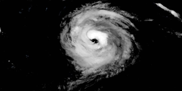
The island of Bermuda can be seen directly in the eye of Hurricane Paulette on Monday, Sept. 14, 2020.
(NOAA/GOES-East)
Those on the island described being in the eye as having “light winds,” with “the tree frogs singing” as the surf continued to roar.
Andrew Moore wrote on Twitter that he could even see “a few stars and planets” after clouds cleared out.
Paulette is currently a Category 1 hurricane with maximum sustained winds of 90 mph, with higher gusts.
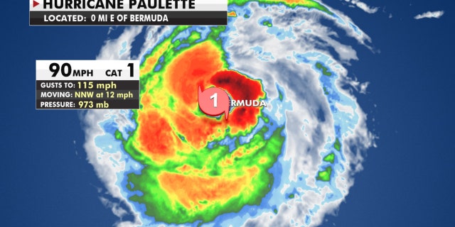
Hurricane Paulette is a Category 1 storm as it’s over Bermuda.
(Fox News)
“Additional strengthening is likely when Paulette turns northeastward and moves away from Bermuda tonight through Tuesday,” the NHC said.
As the storm moves away from Bermuda, hurricane conditions will return to the island from the south and southeast as the southern eyewall passes over.
Up to 6 inches of rain is possible on the island, with hurricane conditions subsiding by mid-morning as tropical storm conditions persist into the early afternoon.
HURRICANE SEASON PEAK: HERE’S WHY SEPT. 10 IS DAY MOST LIKELY TO HAVE A TROPICAL STORM
Paulette may be over Bermuda, but the storm is generating rough seas that will impact the entire east coast of the United States. Life-threatening surf and rip current conditions are possible on Monday.
In addition to Paulette, Tropical Storm Sally is gathering strength as it takes aim at the U.S. Gulf Coast
Once a tropical storm, Rene will dissipate on Monday. with no threat to land.
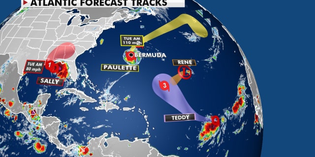
Tropical activity in the Atlantic basin on Sept. 14, 2020.
Tropical Depression 20 strengthened into Tropical Storm Teddy on Monday morning, and was expected to become a “powerful” hurricane later in the week, forecasters said. That storm is forecast to stay in the Central Atlantic with no risk to the U.S. in the next five days.
Yet another disturbance off the coast of Africa, Tropical Depression 21, formed Monday in the eastern portion of the Atlantic Ocean.
CLICK HERE FOR MORE WEATHER COVERAGE FROM FOX NEWS
Historically, September produces the most Atlantic Ocean basin tropical activity. The current name storms have broken records for how early they formed for their respective letter, continuing a trend during the 2020 Atlantic hurricane season.
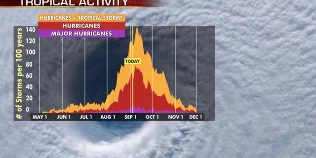
Hurricane season’s busiest month is September, with activity peaking on Sept. 10.
(Fox News)
NOAA forecasters are now calling for up to 25 named storms with winds of 39 mph or higher; of those, seven to 10 could become hurricanes. Among those hurricanes, three to six will be major, classified as Category 3, 4 and 5 with winds of 111 mph or higher.
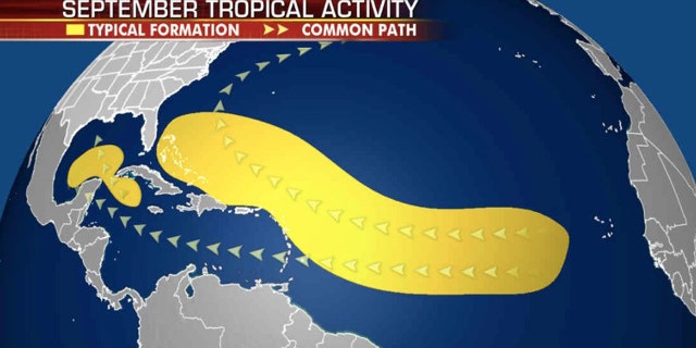
Where tropical storms typically develop during the month of September.
(Fox News)
That’s far above an average year. Based on 1981-to-2010 data, that is 12 named storms, six hurricanes and three major hurricanes.
So far this year, there have been 19 named storms, including six hurricanes and of those, one major hurricane.
CLICK HERE FOR THE FOX NEWS APP
The 2020 Atlantic hurricane season runs from June 1 to Nov. 30 and includes the names Arthur, Bertha, Cristobal, Dolly, Edouard, Fay, Gonzalo, Hanna, Isaias, Josephine, Kyle, Laura, Marco, Nana, Omar, Paulette, Rene, Sally, Teddy, Vicky and Wilfred.
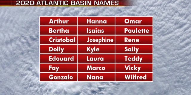
The names for the 2020 Atlantic hurricane season.
(Fox News)
There are only two more names left this season: Vicky and Wilfred. After that, we will move to the Greek alphabet for only the second time in history.
Fox News’ Adam Klotz and Brandon Noriega contributed to this report.
